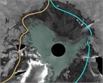
Sep 18: European space agency has released the images of displaying the legendary Northwest Passage.
Arctic ice has shrunk to the lowest level in last 30 years since the satellite imaging was started. New images show the Northwest Passage, a short route between Europe and Asia that was an impassable route in earlier time.
The European Space Agency said that the new images showed an ice-free passage along northern Canada, Alaska and Greenland.
The images collected by European Satellite Agency’s Envisat Satellite showed the ice-free areas in dark gray color while green showed the areas with sea ice.
Leif Toudal Pedersen from the Danish National Space Centre said: "We have seen the ice-covered area drop to just around 3 million sq km which is about 1 million sq km less than the previous minima of 2005 and 2006. There has been a reduction of the ice cover over the last 10 years of about 1,00,000 sq km per year on average, so a drop of 1 million sq km in just one year is extreme.”
"The strong reduction in just one year certainly raises flags that the ice (in summer) may disappear much sooner than expected and that we urgently need to understand better the processes involved."
This imaging has also mark the acceleration of the process of receding, as extension in its coverage in northern winter and receding of the coverage in northern summer is common in a year.
The Northwest Passage across northern Canada is shown fully navigable, while the Northeast Passage along the Siberian coast remains only partially blocked, with this picture the Northwest Passage may be open soon which was earlier predicted to be closed even during reduced ice cover.
The other record reduced ice level was previously marked in 2005.
Arctic and Antarctic are always taken as indicator of climatic changes. It has been earlier predicted that Arctic will be ice free by 2070, however some predicted it by as early as 2040.
The reason behind this receding can be drawn to the fact that the sea ice having a bright surface has greater ‘albedo’ it depend to the extent which it reflects energy but when sea ice melt this energy is traped or absorbe by dark colored ocean surface, as a result temperature rises.
ESA is contributing towards the understanding of the planet and working on its security. It is also associated with International Polar Year (IPY) – a worldwide science programme focused on the Arctic and Antarctic.
Since 2006, ESA has supported Polar View, a satellite remote-sensing programme funded through the Earthwatch GMES Service Element (GSE) that focuses on the Arctic and the Antarctic.
In 2009, ESA will make another significant contribution to cryosphere research with the launch of CryoSat-2.
Opening of this may lessen the voyage route but this is a clear picture of the after effects of GLOBAL WARMING, this legendary sea route has also attracted many on expedition.
Now this opening of the passage seems to be of lesser benefit but of more worry, as Russia already has started claiming the part of arctic sea bed initiating the controversy other countries are likely to jump in claiming the sea bed, exploitation of sea bed for mineral and oil may create conflicts.
null
|
|


Comments: